


The Original Rice Hotel
From site of the Texas Capitol to first-class hotels

The northwest corner of Main Street and Texas Avenue is the location of one of Houston’s most interesting real estate palimpsests. There were two consecutive developments known as the Rice Hotel on Block 57, and three consecutive hotels in total. There is the extant Rice Hotel, known as The Rice and operated as an apartment building in 2021. The first phase of this second hotel was completed in 1913. However, the first Rice Hotel was a renaming of the New Capitol Hotel. Yet a portion of this site was first developed just months after the Houston Town Company sold its first lot on 1 January 1837.
The first development on Block 57 was a capitol building, and it was finished in the Spring of 1837. The Congress of the Republic of Texas met there for a few years before the seat of government was moved to a fledgling town overlooking the Colorado River in central Texas. After the Texas government abandoned the building in Houston, the owners repurposed it as a hotel. This hotel was sold at least two times, was operated by several tenant proprietors, and underwent a number of renovations over its lifetime of over four decades. There were also name changes: Capitol Hotel, Old Capitol Hotel, Enterprise Hotel, and Barnes House. Abraham Groesbeeck redeveloped the site as a five-story hotel on much larger footprint around 1881. William Marsh Rice, the namesake of Rice University, acquired the struggling New Capitol Hotel when Groesbeeck’s hotel sold to pay taxes. Rice renamed the hotel. He still owned this Rice Hotel when he was murdered in 1900. The Rice will conveyed the hotel to a trust for the not yet realized Rice Institute.
Block 57 is a part of the first survey of Houston, laid out in 1836 by Gail Borden (of condensed milk fame) and Moses Lapham. There are ten identically sized lots (50 X 100 feet), numbered one 1 through 10. However with the combined depth of 200 feet, this leaves a corridor of an extra fifty feet in width running north and south. The Borden Survey split this corridor in half, forming two "key lots" with 50 feet of frontage and 125 feet of depth. The first construction on Block 57 commenced in April 1837. One of Houston's founders, Augustus Chapman Allen, owned several lots on this block conjointly with John Allen and General Moseley Baker. AC Allen contracted with Thomas William Ward to build the capitol building at the northwest corner of Main and Texas. The blue shaded area on the map above is the approximate footprint of the original structure, occupying most of Lots 1 and 2, and a small part of Lot 12.

Map of Block 57: Drawn by the author with a southern orientation to match the original Borden Survey.
Baker sold his interest in this real estate partnership shortly thereafter and John Allen died in 1838, leaving AC Allen as the sole owner of the property. He conveyed the Capitol property to his wife, Charlotte, as a part of an informal separation agreement in the 1850s. After the seat of government removed to Austin, the Allens repurposed the property as a hotel, most likely leased to professional hotel managers. Charlotte Allen sold it to Reading S Blount in 1857. While the property may have changed ownership sometime in the 1860s, Abraham Groesbeeck definitely owned it in 1881.

1869 Wood Map of Houston (northern orientation): The red arrow points to the Old Capitol Hotel on the northwest corner of Main and Texas in downtown Houston. The hotel was a short walk from the City Market/City Hall and the Harris County Courthouse. The map also depicts the legacy of a failed horse railcar company.

1873 Birdseye Map of Houston (Augustus Koch): This map has a southern orientation. The large building within the circle and to the left is the Old Capitol Hotel. The building to the right within the circle represents the stables. The numbered buildings are: 3 Masonic Building, 8 Baptist Church, 9 Methodist Church, 10 German Lutheran Church, 31 Henry House Planing Mill, 32 Bering brothers Door and Sash Mill
Various tenant proprietors invested in renovations, and some of these must have included changes to the building's footprint and facade. It was also known as the Enterprise Hotel and Barnes House in the 1870s.

1877 Sanborn Map of Houston: The Old Capitol was a much larger building according to the 1873 map. It appears that the hotel was renovated after 1873 and reduced in size. The Barnes Hotel included space for several ground leases: a saloon, an ice cream saloon, a barber, a cigar shop, and a confectionary. Yellow indicates wooden structures and magenta indicated buildings clad in brick.
Abraham Groesbeeck (or Groesbeck), a friend of William Marsh Rice, bought the Old Capitol Hotel in 1881 and built a New Capitol Hotel from the foundation up, taking up a much larger footprint. This five-story, brick-clad hotel spread out over about forty percent of Block 57, and opened in 1882. The architect was George E Dickey. Groesbeeck committed $125,000 to the project. In 1885, the hotel reserved first-floor space for a large laundry and a large dining room, and a small area in the middle of the block for a kitchen, bake house, engine, and boiler. The business plans for hotel developers included revenue from ground leases. The New Capitol Hotel in 1885 leased space to a barber, a drug store, a clothing store, a shoe and boot store, two billiard saloons, and two millineries.

1885 Sanborn Map: The earliest extant map of the New Capitol Hotel, which replaced the Old Capitol Hotel around 1881. The hotel was adjacent to a carriage manufacturer. This is an indication that it was legal to locate noisy industries near hotels.

1890 Sanborn Map: The building for the carriage factory was still in tact, but its use was not noted on this map. The yellow corridors indicate covered plank sidewalks.
The health of the New Capitol Hotel and of Abraham Groesbeeck were failing. Unable to run the hotel profitably, Groesbeeck surrendered it in a tax sale on 23 January 1886. William Marsh Rice, who had been his business partner in the 1850s, purchased the hotel property from Groesbeeck, who died later in 1886.
After the Civil War, Rice established primary residences in New Jersey and New York, where he lived with his second wife, Elizabeth “Libby” Baldwin Rice, a niece of Charlotte Baldwin Allen. However, Rice spent a significant amount of time in Houston during the 1880s and 1890s, and he established the New Capitol/Rice Hotel as a second home. Unsatisfied with his accommodations at the hotel, he demolished the old stables on Travis Street and erected a five-story annex in 1893. He established his own apartment in the new annex. This basic layout was still maintained after Rice's death.
1896 Sanborn Map of Houston: Notice the difference in the street numbering compared to the 1890 map. In 1892, the City of Houston imposed a coherent street numbering system for the whole city, which had been ad hoc street numbering prior to 1892. The numbering from 1892 is still used today.
William Marsh Rice, the founder of Rice University, had owned the Rice Hotel and included this property in his bequest to the trust for the planned institute of higher learning. Rice University opened its campus to students in 1912, about twelve years after the murder of its benefactor in New York City. Sanborn Fire Insurance Company published a map in 1907, and the image below is clipped from it. This is the first building known as the Rice Hotel at this site. However, the development of this block began seventy years before.
The footprint of the Rice Hotel occupied more than half of Block 57, part of the first survey of Houston, executed in the fall of 1836. Block 57, like most of the blocks laid out in the 1836 survey, is 250 x 250 feet. Block 57 was originally subdivided into twelve lots. Five lots of identical dimensions fronted Main Street (to the right of the block), and another five identically sized lots fronted Travis Street (to the left of the block). These were all 50 feet wide and 100 feet deep. It also included a key lot, with dimensions of 50 feet of frontage and 125 feet in depth.

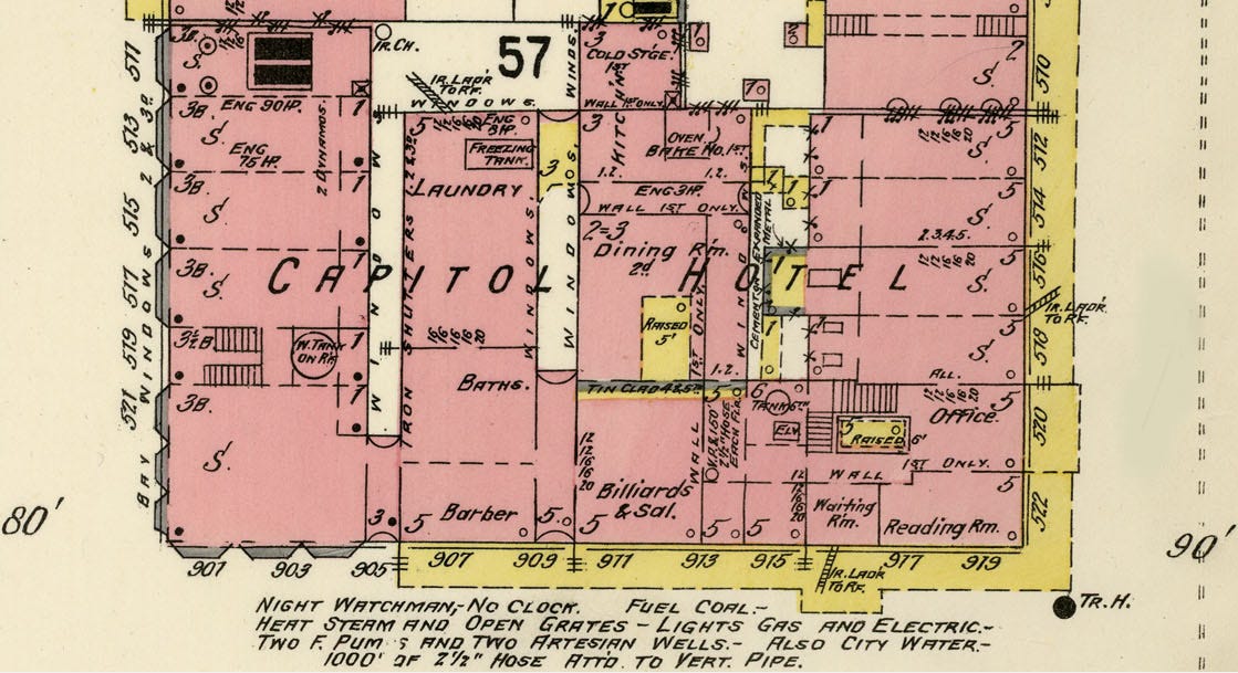
1907 Sanborn Map: renamed as the Rice Hotel. The magenta shading indicates a structure with brick cladding. Yellow shading documents wooden structures. The yellow corridor at the outside of the building are covered plank sidewalks. The building was five stories high.
Louis F. Aulbach, Buffalo Bayou: An Echo of Houston’s Wilderness Beginnings (Houston: Louis F. Aulbach, 2012).
Barrie Scardino Bradley, Improbable Metropolis: Houston’s Architectural and Urban History (Austin: University of Texas Press, 2020).
Stephen Fox, Houston Architectural Guide (Houston: American Institute of Architects, Houston Chapter, 2012).
Joe B. Frantz (ed.), “Moses Lapham: His Life and Some Selected Correspondence, I.” The Southwestern Historical Quarterly 54:3 (January 1951), 324–32.
Randal Hall (ed.), William Marsh Rice and His Institute: Centennial Edition (College Station: Texas A&M University Press, 2012). Sylvia Stallings Morris edited the first edition, based on the notes of Andrew Forest Muir.
David C. Humphrey, Peg Leg: The Improbable Life of a Texas Hero, Thomas William Ward, 1870-1872 (Denton, TX: Texas State Historical Association, 2009).
David G. McComb, The City in Texas: A History (Austin: University of Texas Press, 2015).
David G. McComb, Houston: A History (Austin: University of Texas Press, 1981).