


The First Railroads in Texas
Harrisburg was the spearhead

Edited and republished 25 June 2024.
Buffalo Bayou, Brazos, & Colorado Railway
Augustus Chapman Allen and John Kirby Allen—together, the majority investors and managing partners of the Houston Town Company—fantasized about railroads for Houston as early as they even had the idea for Houston in 1836. By the end of the year, a group including Stephen F. Austin and four Texas Republic government officials formed the partnership and successfully applied for a charter for the Texas Railroad Banking and Navigation Company. But the first construction work on a railroad in Texas was planned instead for an eastern terminus at Harrisburg, Texas, about four miles downstream from Houston on Buffalo Bayou at the mouth of Braes Bayou. The first track for the Buffalo Bayou, Brazos & Colorado Railway (BBB&C) was laid in the 1850s and service began in August 1853.
The original BBB&C right-of-way survives as a functional freight railroad. This railroad segment changed ownership several times. The Galveston, Houston, & Antonio bought it before it was absorbed by the Southern Pacific Railroad. The Union Pacific acquired it in their takeover of the Southern Pacific. Today this right-of-way is part of the Union Pacific-Glidden Subdivision.1

Image 1. The first segment of the BBB&C ran from Harrisburg to Stafford’s Point, and was later extended further west. Those tracks are now a part of the Union Pacific system and operated as the Glidden Subdivision. (Image credit: Houston Region Freight Rail Study, Texas Department of Transportation. One note added by the author.)
Houston Tap Railroad
While the first segment of the BBB&C ran only as far west as Stafford’s Point, this still reduced the distance that produce needed to travel by wagon to Houston and the railroad company committed to extending it west across the Brazos River and toward the Colorado River. This was the most desirable land for growing cotton and sugar. Although a few Houston capitalists also maintained investments in Harrisburg, most Houston merchants were envious of the railroad serving Harrisburg and they quickly organized a response. Instead of competing directly with Harrisburg and the BBB&C, these Houston merchants proposed to “tap into” it. Around 1856, the State of Texas passed a law allowing the City of Houston to levy a local tax for the purpose of constructing a railroad. Allen & Brocket, editors of the Telegraph in Houston, were most enthusiastic boosters of this planned municipal railroad as a means of controlling the commerce in the region, with inbound freight of sugar and outbound freight of lumber. Mayor James Stevens issued the first request for proposals on 5 March. The Houston Tap was already in operation on 21 October. The City of Houston, however, remained in the railroad business for about two years, and sold its interests to a company organized as the Houston Tap & Brazoria Railway (HT&B).2
The first map to depict the Houston Tap depot was published by W. E. Wood in 1869. It depicted a depot in the west side of San Jacinto Street, between Dallas and Polk avenues. A small shop was located on Block 273 next to a turntable. The first segment of the railroad, the “tap,” allowed passengers and freight from Houston to transfer to the BBB&C at Peirce Junction, about 6.5 miles of track from its origin in Houston. This segment was completed in 1856. More track was completed to Bonney in 1858, Chenango in 1859, and east Columbia in 1860, which was the furthest extent of the railroad. Informally, locals called this railroad the “Houston Tap,” the “Columbia Tap,” the “Columbia Road,” and the “Sugar Road.”3

Image 2. Clip from the 1869 W. E. Wood Map of Houston showing the Houston and Brazoria Tap Railroad (H&BT) depot. (Image source: Beinecke Rare Book and Manuscript Library, Yale University. Annotations by author.)
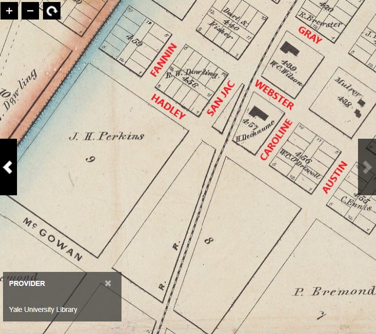
Image 3. The H&BT started its long sweeping curve as it approached Gray Avenue.(Image source: Beinecke Rare Book and Manuscript Library, Yale University. Annotations by author.)

Image 4. The H&BT cut the intersection of Tuam and Austin through undeveloped prairie just north of the southern corporate limit. (Image source: Beinecke Rare Book and Manuscript Library, Yale University. Annotations by author.)
Abandonment

Image 5. 1873 Houston Birdseye Map showing the Houston Tap property with the roundhouse still in place at San Jacinto Street and Polk Avenue.
The Houston & Great Northern Railroad bought all fifty miles of the H&BT in 1873, which was later that year merged with several other lines and renamed the International & Great Northern Railroad. It is difficult to date the abandonment of the Houston Tap, but all traces of the tracks on San Jacinto and rail facilities on Block 273 were gone by 1890.4

Image 6. 1890 Sanborn Map of Houston. (Image credit: Library of Congress.)
HNTB Corporation (prepared for the Texas Department of Transportation), “Houston Region Freight Study,” 9, (4-19)-(4-21).
The Weekly Telegraph (Houston), 6 February 1856. Page 1, Column 6; Houston Telegraph, “Steam Dredge.” “The Tap Road,” “Every Man for Himself and the Devil Take the Hindmost,” 20 February 1856; The Weekly Telegraph (Houston), “Notice to Contractors,” 12 March 1856. Harvey H. Allen, a younger brother of the founders with the same surname, acquired the Telegraph press from Francis Moore, Jr. in 1854. “Telegraph and Texas Register,” Handbook of Texas Online, 12 June 2018.
Charles P. Zlatkovich, Texas Railroads: A Record of Construction and Abandonment (Austin: Bureau of Business Research, 1981), 26, 74.
Zlatkovich, Texas Railroads, 73-5.