Gail Borden and Moses Lapham surveyed the town site of Houston in October 1836 on the south bank of Buffalo Bayou, with the head of Main Street as the focal point of the survey. Main Street was aligned with the mouth of White Oak Bayou in a northeasterly direction. Texas Avenue marked the southern edge of the survey, Buffalo Bayou was both its western and northern limits, and the eastern boundary formed by the not yet named Crawford Street.1
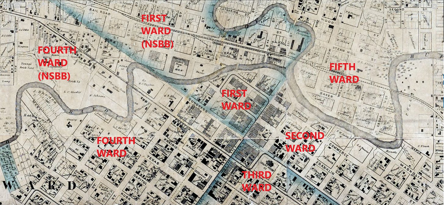
From 1839 through the end of the nineteenth century, Houston administered municipal government through a system of wards. In 1839, the four-ward system was formalized through a charter with the Republic of Texas. The original Houston townsite—also known as Houston, South Side, Buffalo Bayou (or Houston SSBB)—was split into four quadrants for administrative purposes. The ward boundaries were formed by two perpendicular axes: Main Street and Congress Avenue. The northwest quadrant formed by these axes was named the First Ward, with the other wards numbered in clockwise order (Image 1). Another provision of the 1839 charter expanded the town limits to nine square miles. The axis defined by Congress Avenue extended in a line running west (or closer to northwest by compass point), crossing Buffalo Bayou, extending the First Ward and Fourth Ward to the land on the other side of Buffalo Bayou. These extensions were known as First Ward, NSBB and Fourth Ward, NSBB.2
Houston added the Fifth Ward in 1866. While Fourth Ward, NSBB was replaced by the Sixth Ward in 1877, this ward did not elect aldermen until 1896, so the five-ward administrative system was in effect in 1880 for the purpose of elections. More important to historical researchers, however, the 1880 census enumerators did not recognize the Sixth Ward.3
Houstonians continued with the language of the wards long after the city abandoned them as the basis of municipal elections and administration; however, these names took on new meanings and referred to different areas compared to the historic wards. For example, “First Ward” today refers to the historic First Ward, NSBB. Similarly, “Second Ward” today refers to a part of the historic Second Ward, but not all of it, including the part of the Second Ward that was home to many ethnic Germans, who were replaced by Mexican immigrants during the long revolutionary period in Mexico, starting around World War I. The present-day meaning of Third Ward is difficult to discern. The historic Third Ward was the most residential of the original four wards, and it was these neighborhoods that yielded the most to twentieth-century parking lots and freeway development. The largest redevelopment projects in the historic Third Ward are Houston Center, the George R. Brown Convention Center, Toyota Center, and Discovery Green. Meanwhile, the present-day meaning of “Third Ward” invokes the large area around Texas Southern University as well as the portion of Midtown east of Main Street. Present-day Fourth Ward is Freedmen’s Town. Present-day Fifth Ward is the most difficult to discern of the historic wards. Much of the present-day area understanding of the Fifth Ward lies outside of the 1866 city limits.4
Image 1. Section of the 1869 W. E. Wood Map of Houston. The blue shaded corridors mark the axes of the ward divisions of the four-ward system on Main Street and Congress Avenue. The Fifth Ward is the area of Houston north of Buffalo Bayou and east of White Oak Bayou. Image source: Houston History Research Center, Digital Archives. Annotated by author.
Joe B. Frantz, Gail Borden: Dairyman to a Nation (Norman: University of Oklahoma Press, 1950), 122-3; Joe B. Frantz, ed. “Moses Lapham: His Life and Some Selected Correspondence, I.” The Southwestern Historical Quarterly 54, no. 3 (January 1951): 326-7; Joe B. Frantz, ed. “Moses Lapham: His Life and Some Selected Correspondence, II,” The Southwestern Historical Quarterly 54, no. 4 (April 1951): 468-9; Barrie Scardino Bradley, Improbable Metropolis: Houston’s Architectural and Urban History (Austin: University of Texas Press, 2020), 12-3; David G. McComb, Houston: A History (1969; Austin: University of Texas Press, 1981), 13-4; Steven Cook, “The Audacious Launch of the City of Houston: Capitol of the Republic of Texas,” Southwestern Historical Quarterly 121 (October 2017): 132-3.
McComb, Houston: A History, 51; Betty Trapp Chapman, “When There Were Wards: A Series,” Houston History Magazine, 8, no. 1 (2010): 29; Betty Trapp Chapman, "A System of Government Where Business Ruled," Houston History Magazine, 8, no. 1 (2010): 30;
Chapman, “A System of Government,” 30.
Betty Trapp Chapman, "Houston's First Ward: Producing Food from Farm to Counter." Houston History Magazine, 8, no. 1 (2010): 34–7; Debbie Harwell, “Beauty in the Eye of the Beholder: Third Ward Treasure but a Memory,” Houston History Magazine 8, no. 2 (2010): 36; Tomiko Meeks, “Freedman’s Town, Texas: A Lesson in the Failure of Historic Preservation,” Houston History Magazine 8, no. 2 (2010): 42–4; Thomas McWhorter, “From Das Zweiter to El Segundo, A Brief History of Houston’s Second Ward,” Houston History Magazine 8, no. 1 (2010): 38–42; Ezell Wilson, “Third Ward, Steeped in Tradition of Self-reliance and Achievement,” Houston History Magazine 8, no. 2 (2010): 31–5; Patricia Pando, “Two Worlds a Mile Apart, A Brief History of the Fourth Ward,” Houston History Magazine 8, no. 2 (2010): 37–41; Cary D. Wintz, “Fourth Ward,” updated 22 October 2020, Handbook of Texas Online.


