


Bagby Street, Houston, TX
Using Engineering to Tame Nature

Edited 28 April 2022.
Other posts about Houston history:
An Elite Mansion, A Courthouse, and A Brewery
Restaurants in Victorian Houston
Bagby Street refers to a pair of discontiguous right-of-ways in Houston. One of these is a funnel for receiving arterial traffic from west into downtown and is renamed as West Dallas as it changes direction toward Freedmen’s Town. The second of these has a northern terminus at the top of Midtown and dead ends in Montrose. This essay is about Bagby in downtown. In my opinion, there are two important narratives regarding the history of Bagby. The earlier narrative is its part of a neighborhood with a large black population. This is very compelling, but I only raise this question more than I attempt to answer it. The later narrative is how we planned and engineered Bagby to tame nature, which is the subject of this essay.
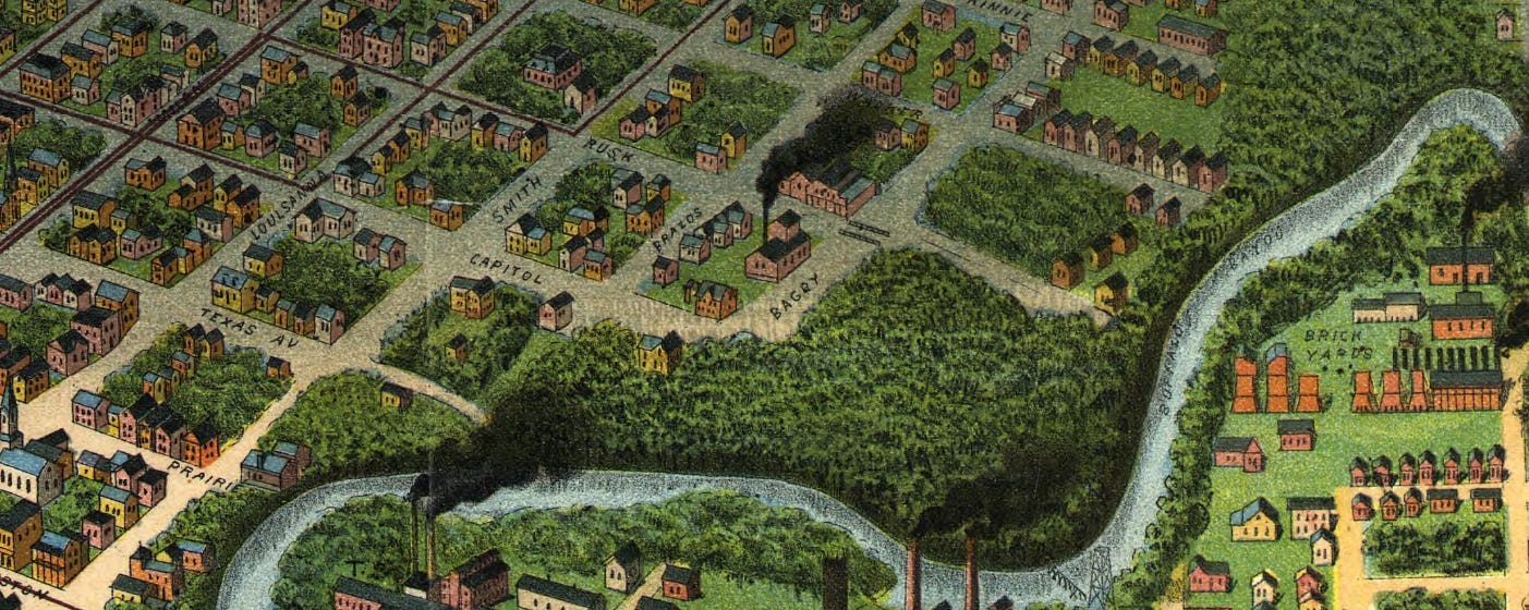
Bagby Street in downtown Houston is not labelled on the Borden Survey of Houston. The northern part of the easement was already defined in 1836 and 1837, but the name “Bagby” does not appear on the map and this street was at that time not named. Thomas Bagby (1814-1868) was a native of Virginia, but grew up in Montgomery County, TN. Bagby arrived in Houston in 1837 and worked as a clerk for the Houston Town Company, the founding partnership of Houston. One local historian imagines that Bagby was a keeper of the account book recording the sales of Houston lots. Bagby later worked as a cotton factor and was an investor in the Houston Direct Navigation Company. He served as an alderman for the Fourth Ward in 1866. This all indicates his notability through his life in Houston, but also his lack of notability when Gail Borden created street names for his 62-block survey in 1836/1837.

Borden Map, 18 January 1837. This is a correction of a map that was circulating in Columbia, Texas in November 1836. Thomas Gazley signed as a witness. James Holman and John Allen signed on behalf of the Houston Town Company. This map was drawn with a southern orientation. The easement now known as Bagby Street is implied by this map on the far right. Blocks 39 and 62 had gullies, but these were not depicted on this map. Lower Brazos Street no longer exists.
In haste to prepare a proposal to the Republic of Texas Congress for the temporary capitol, the Allen brothers dispatched Gail Borden and Moses Lapham to the town site to conduct a survey. The surveyors did not even have all the proper equipment, likely pitched into Buffalo Bayou with the Borden printing press by Santa Anna’s troops in Harrisburg during the Runaway Scrape. These deficits in equipment compromised the accuracy of the map, but the accelerated timeline also induced some sloppy field notes. The Borden Survey failed to map an accurate depiction of the bayou and even included a long wedge of land that the Houston Town Company did not own in the Obedience Smith Survey. With an incorrect course of the bayou, the map misrepresented the land mass slightly, enough to exaggerate the number of lots and the size of some blocks along the banks. Furthermore, the map failed to document the various gullies which split the townsite. Gullies are dynamic land features, so we cannot know their specific dimensions during the Republic. However, there are enough contemporary mentions of them to support their existence. The most prominent gullies were in the southwestern portion of the survey, which explains much of the history of what would later be known as Bagby Street.
After the Republic of Texas granted Houston its first municipal charter, Houston divided the townsite into four wards. It was a simple division of the original survey into four wedges by two axes: Congress Avenue from west to east, and Main Street from north to south. The right-of-way later known as Bagby was one of just two north-south streets contained wholly within the Fourth Ward. While I do not drill down on this idea in this essay, it is worth raising the question about the relationships between the redefinition of Bagby Street over time, changes in development facing Bagby Street, and the evolution of the social meaning of “Fourth Ward” in Houston.
In 1839, Auguste Girard did a partial survey for an expansion of Houston, but was forced to discontinue his work after suffering a debilitating stroke. This map recorded a more accurate course of Buffalo Bayou, revealing problems with the depictions of some of the blocks on the Borden Map, which exaggerated the number of developable lots within the 62-block survey. Girard named the north-south street parallel to Brazos as “Calhoun” Street and renamed Brazos as “Clay” Street (later “Clay Street” was used for another street). Though Girard drew a gully on Clay Street, he likely understated the gullies which ran through this part of Houston. Of course, Calhoun Street was later renamed Bagby Street and like “Clay,” the name “Calhoun” was allocated to another street. The Girard Survey extended Houston to as far south as the row of blocks fronting McKinney Street. He also created the numbering anomaly for blocks 144, 145, 146, 147, 148, and 149.
There is a three-decade gap between extant maps of Houston. CE Wood published a survey of Houston in 1869. Though Bagby was not yet named on this map, Wood depicted it as a street, but one that narrowed at the intersection of Walker. He noted a narrow gully running through Block 87. Brazos was still a street running through the First and Fourth wards.

1869 Wood Map of Houston. I added street labels in red. The railroad tracks were laid for mule streetcars, though this first company only operated service for weeks before folding. This right-of way was later used by other streetcar companies and still marks the inbound or eastbound routes of the 40 and 41 bus routes. Bagby and West Dallas (formerly San Felipe Road) are both two-way streets and handle two-way bus traffic. McKinney and most other west-east streets in downtown are one way.
This map fragment shows how the eccentric north-south axes following the 1836 Borden Survey meets with the true east-west orientation of the Seneschal Addition, part of Freedmen’s Town. Though Bagby died in 1868, this map shows his homestead on Block 147, the current location of the Julia Ideson Building. San Felipe Road is now called “West Dallas.” The Heritage Society at Sam Houston Park is now located on the west side of Bagby, with its offices between Lamar and Dallas, directly opposite of the Texaco Heritage Building However, the street name “Bagby” was not recorded on this map. Bagby died in 1868, the year before the publication of this map. (Red text is mine.) The railroad tracks were laid by the first Houston mule railcar company, although this company failed after just weeks in service. But this route was later used by later streetcar companies, and two present-day local buses (routes 40 and 41) follow the same right-of-way on their inbound segments.

1873 Birdseye Map of Houston. Bagby was discontiguous since there was no bridge over the deep gully. The large circled area refers to a pair of the main cemeteries of the day, part of which is now Sam Houston Heritage Park and part of which is the McKinney Avenue offramp for I-45 southbound. The circled building is a black church serving the neighborhood.
This 1873 version of the Birdseye Map captures more natural features. What is important here are the drainage features. There is a large and deep gully running between Walker and Rusk. There is no bridge over the gully, which makes Bagby discontiguous. The large circle highlights the Episcopal and Methodist cemeteries, now the location Sam Houston Heritage Park. The building within the red capsule is the “Colored Church.” With the gully on one side and Buffalo Bayou on the other, some of these blocks are isolated. South of Walker and east of Bagby is currently the City Hall property. West of Bagby is currently the City Hall Annex.
1891 Birdseye Map of Houston (originally identified as 1873). This Birdseye map is highly idealized and omits important drainage features.

1896 Sanborn Map, Facet 20. The irregular lines depict the ridge lines of gullies.
This map has a western orientation. However, the northern terminus of this street is Buffalo Bayou, just as it was in 1837, 1869, and 1873. Or rather, the street terminated at the ridge of the ravine overlooking Buffalo Bayou. In 1896, Bagby did not extend through the block between Capitol and Rusk just as in 1873. Similarly as with 1873, there is large and deep gulley running between Walker and Rusk, though on the 1896 Sanborn Map it was represented as two distinct gullies and with no interruption to Rusk Avenue. I believe this map was very accurate in representing street and geographical features.
This neighborhood was geographically isolated from much of Houston. There was no bridge over Buffalo Bayou directly connecting this enclave of the Fourth Ward with the part of the Fourth Ward north of Buffalo Bayou. In addition to the constraint of Buffalo Bayou, large gullies feeding the bayou split this neighborhood and some of its blocks. This indicates that the maps representing Republican Houston exaggerated the extend of developable lots and blocks. Certainly drainage features are very dynamic, so their precise shapes are expected to change. Second, contemporary accounts from the Republic refer to gullies in this area. Therefore, the gullies existed in some form during the Republic and the cartographers omitted them.
The geographic isolation was not doubt an advantage as the location for the Harris County Jail, which is the magenta-shaded building depicted on the 1896 map. This brick-clad structure lay at the western terminus of Capitol Avenue, bound to the north and west by Buffalo Bayou. One of the gullies isolated the property from the south. Capitol Avenue was effectively the one way in and one way out from the jail. The Sanborn map shows how the edge of a ravine impedes the development of some of the lots on Blocks 63 and 86, a gully reduces the developable land on Block 88 by about a third, and prevents the development of most of Block 87. In general, this part of Houston was threatened by the movement of water finding its way into Buffalo Bayou. Therefore, the highly idealized Borden map and even the more realistic Girard Map both failed to depict the drainage of Bagby and the neighborhood.
Knowing the specific locations of residences prior to Reconstruction Houston is rare. The first City Directory was published in 1866, and even these listings are vague or misleading. The first map helpful in locating residences and building footprints was published in 1869. But we know the specific location of a few antebellum residences in this neighborhood. The Kellum-Noble House is the oldest building in Houston at its original location. We know the location of the Bagby homestead. It is possible that this neighborhood included many successful merchants: in addition to Bagby, William Van Alstyne, Thomas William House, Sr, probably lived in this neighborhood. Yet there were also tradesmen living there. Nelson Kavanaugh, one of about five free blacks living in antebellum Houston, probably lived among these merchants. But most of this is conjecture and we do not have enough information to understand this neighborhood or even certainty about many of the people who resided here during the antebellum era.
Even the city directories clarify residential location only somewhat. Most address (but not all) listings are helpful. But the Reconstruction-era directories are insufficient for a thorough mapping of neighborhoods. There is what I call “the disposition to report.” People chose whether to be listed in the city directory and what personal details to offer. Therefore, the city directories provide a skewed sample of Houston residents. The persons most disposed toward reporting were white males, but they were less likely to report on the lower ends of the occupation hierarchy. So the city directories underreported residents who were not well-off white males.
The 1870 census for the first time reports all of Houston’s black residents as persons. In the 1850 and 1860 censuses, many slaveholders lived in Houston and their human chattel was reported as a part of the Houston population. The Constitution defined a slave as 3/5 of a person for the purpose of apportionment. This had two implications. First, there was a legal requirement to include slaves in the census. Second, slaves were not equal as persons in the law with freeborn persons, so slaves were counted separately. In 1850 and 1860, the census reported enslaved persons on a slave schedule. All of the free blacks (perhaps 5-10, total) were recorded on the regular census schedule. With emancipation, all blacks living in Houston appear in the 1870 census. We know the residences of blacks by ward, but because they only rarely published their personal information in city directories, precise residential location is rarely known for blacks, even in 1870.
The 1880 and 1900 censuses allow us to know residential locations much better. The enumerators for the 1880 census recorded street names in the margins. This information improved for the 1900 census. In addition to street names, the 1900 census enumerators recorded rational address numbers. While I have not studied either the 1880 or the 1900 census carefully, I have seen enough samples of these records to know that many blacks lived in the Bagby corridor during these last decades of the nineteenth century. In addition, this was a neighborhood for many black businesses.
Neither Bagby nor any of the streets on Facet 20 of the 1896 Sanborn map was paved. But that was not unusual. While there was a street paving program implemented in the mid-nineties, street blocks were more often nonpaved.
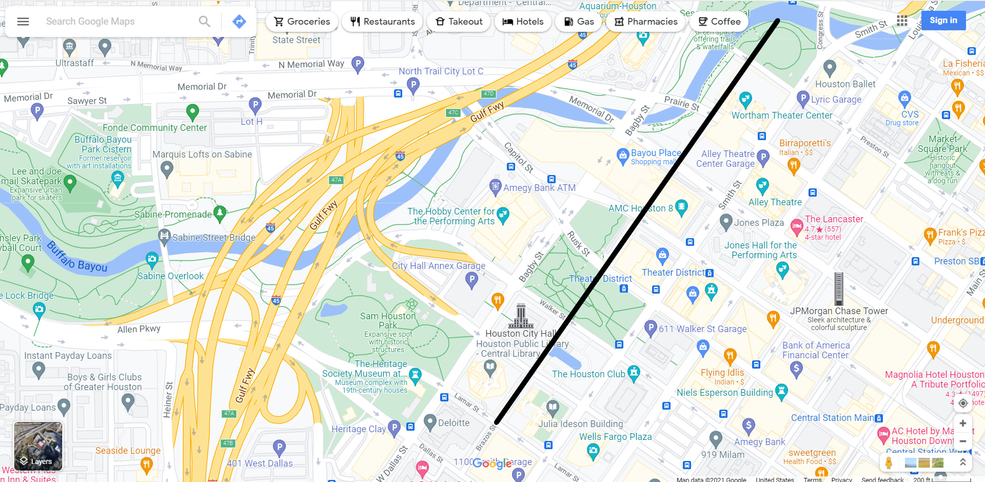
Google Map. The black line approximates the abandoned Brazos Street easement. This facilitated superblock development for the Wortham Theater, the Alley Theater, the Albert Thomas Convention Center, the Casey Federal Court Building, Tranquility Park, City Hall and its grounds, and the Houston Public Library Complex.
Present-day Bagby Street is basically an arterial serving high volumes of traffic just as other streets in downtown Houston. Washington Avenue, formerly known as Washington Road, is a corridor which served as a highway between Houston and Washington, Texas throughout the nineteenth century. It is a high-volume arterial posted for 30 mph, but from two blocks east of downtown to its junction with Preston, this arterial includes two general traffic lanes in each direction and a center turn lane. Traffic probably flows at 45mph, and some drivers travel at highway speeds. Washington meets at an obtuse angle with Preston into downtown, a continuation of the high-speed design of Washington. For those driving south on Bagby, they are attempting to carry similar speeds as they travel through downtown. West Dallas has a slightly less accommodating design for high-speed driving. It has four general traffic lanes, but with no center turn lane. There are also a few more traffic lights on West Dallas compared to Washington. However, West Dallas and Washington and both designed to facilitate volume and a decent amount of speed, even if Washington is most like a highway of the two. Bagby receives high-speed traffic entering both sides of downtown.
High volumes of traffic cross Bagby going to and from various expressways. McKinney Avenue receives traffic from Interstate-45 South passing between Sam Houston Heritage Park and the Houston City Hall Annex. Walker Avenue connects to the on-ramp for Interstate-45 North and the access road to high-speed Allen Parkway. Cars shoot into downtown at high speed from Memorial Drive over the Texas Avenue Bridge, and drivers zip on Prairie hoping to beat the light before the bridge to Memorial drive outbound. Dallas and Lamar avenues dispatch high-speed traffic to and from Allen Parkway. Anyone walking, riding a wheelchair, or riding a bike confronts impatient drivers who are anxious to speed up for the freeways or reluctant to slow down after enjoying freeway speeds.
Fortunately, the City of Houston recently completed installation of a Complete Streets treatment on Bagby Street. The city added a center island on one block. For several blocks, they reallocated one general traffic lane to a wider sidewalk and a raised bike lane in each direction. This treatment of Bagby is an important corrective to the high-speed and impatient driving in this part of downtown. The city added these features without making the right-of-way any wider. However, the city did not make the right-or-way any narrower, either. There are still many characteristics of Bagby and intersecting ROWs which read as high-speed roads. In addition, drivers are reluctant to slow down when they whet their appetite for speed. Therefore, there is a network problem here. The Bagby Complete Streets Project, however, demonstrates that the City of Houston and the Downtown Management District are willing to allow staff planners to try a bold approach. Now we need to continue to improve safety for the network in the west part of downtown. Yet, even with these important new safety features on Bagby, Bagby suffers from network effects from the high-speed arterials and highways feeding the west part of downtown. Second, while a general lane was reallocated as a grade-separated pedestrian and cycling facility, the ROW is no less narrow, and the wide open interstices between the buildings and other hard objects still leave drivers too comfortable with driving too fast.

Bagby bike lanes east of the Aquarium. (Photo credit: Jon Boyd).