Second Ward Railroads
The International & Great Northern Railroad and the Galveston, Houston, & Henderson Railroad
This is part of a series on residential boarding in Houston in 1880. This study of 1880 Houston is limited to the twelve hotels in the city. The focal point of two of the hotels in this study was the Second Ward railroad complex. This is a brief history of the Second Ward railroads.
Other parts of the series:
Hotels of 1880 Houston: An Introduction
Andre Sens and Charles Bente, Houston Hotelkeepers
Hotels of 1880 Houston: First Ward
Hotels of 1880 Houston: Second Ward
William Dissen, Houston Hotelier
Hotels of 1880 Houston: Third Ward
Hotels of 1880 Houston: Fourth Ward
John Lyons, Grocer and Hotelkeeper
Hotels of 1880 Houston: Lyons House
William J Hutchins, Merchant, Investor, and Hotelier
Hotels of 1880 Houston: The Finest
Hotels of 1880 Houston: Conclusion
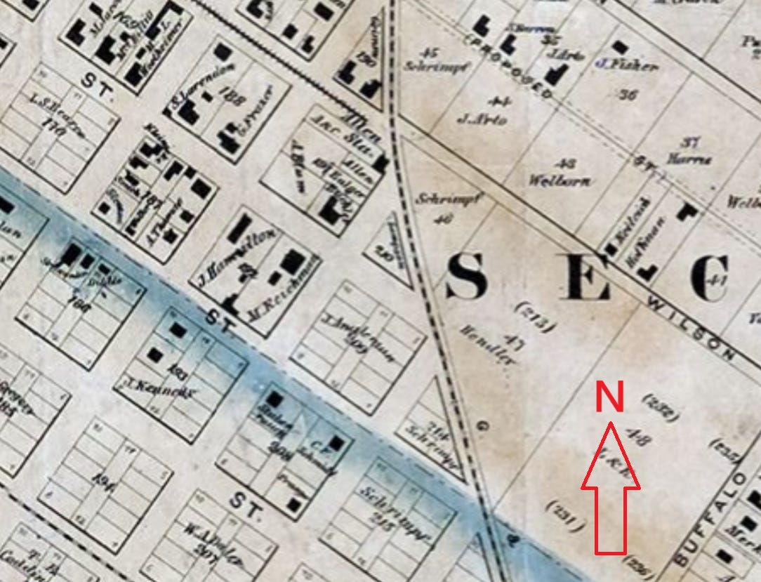
Image 1. “W. E. Wood Map,” 1 January 1869. Only one railroad operated through the Second Ward in 1869: the Galveston and Houston Junction. The other tracks visible on Franklin Avenue were vestiges of an abandoned mule car line. Image source: Houston History Research Center, Digital Archives. Annotated by author.
Only one railroad was constructed in the Second Ward before the Civil War. While the Galveston, Houston & Henderson (GHH) built north from Virginia Point toward Houston, when they added a spur into Houston in 1860, they ran it west through the Third Ward on McKinney Avenue. Five years later, the first railroad tracks were constructed in the Second Ward when the Galveston & Houston Junction Railroad built just two miles of iron road. These tracks ran northwest into the city, then nearly due north (Image 1). This was the only completed railroad tracks within the Second Ward through 1869. There were still no yards, shops, or depots developed there by 1869.1
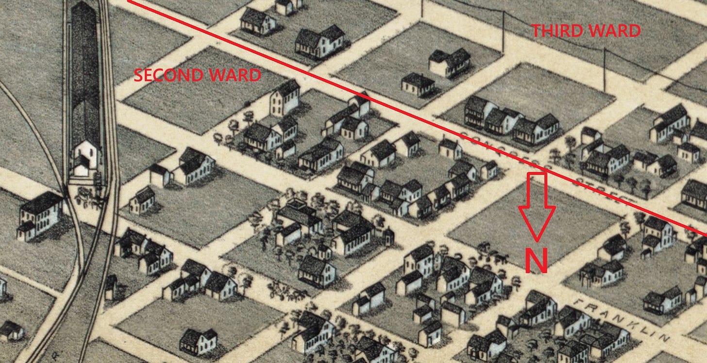
In the 1870s, a small railroad complex emerged in the Second Ward after corporate consolidation. The Houston & Great Northern, founded in 1866, completed its first fifty-five-mile segment from Houston to New Waverly in 1871. The same year, the GHH acquired the Galveston and Houston Junction. Instead of operating its spur into the heart of town, it used the Galveston & Houston Junction for both access to and through town. The Birdseye Map depicts the depot shared by the International & Great Northern Railroad and the GHH (Image 2). Their depot was located in the eastern part of the Second Ward, between Congress and Commerce avenues. The International & Great Northern Railroad (IGN) was formed in 1873 from a merger of the International Railroad and the Houston and Great Northern Railroad. The International Railroad developed about 177 miles of road, running west from the Brazos River through Hearne, Palestine, and Longview. The Houston and Great Northern accumulated 253 miles of road by 1873, including the acquisition of the Houston & Columbia Tap Railroad, as well as track it developed from Houston, running north to New Waverly, Crockett, Palestine, Troup, and Mineola. However, the most important piece of the IGN was the draw bridge over Buffalo Bayou connecting the Second Ward depot with tracks leading through Houston’s Fifth Ward, which the Houston and Great Northern completed in 1872. The Galveston, Harrisburg & San Antonio was the third railroad to operate into and through the Second Ward when it started leasing tracks from the IGN. In 1880, the Galveston, Harrisburg & San Antonio started building its own tracks and depot.2
Image 2. Augustus Koch, “1873 Birdseye Map.” The red line represents the axis dividing the Second Ward and the Third Ward. At the left is the depot for the X railroad. Annotated by author. Image source: Wikipedia Commons.
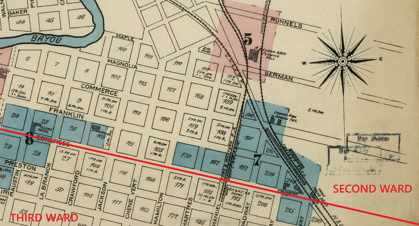
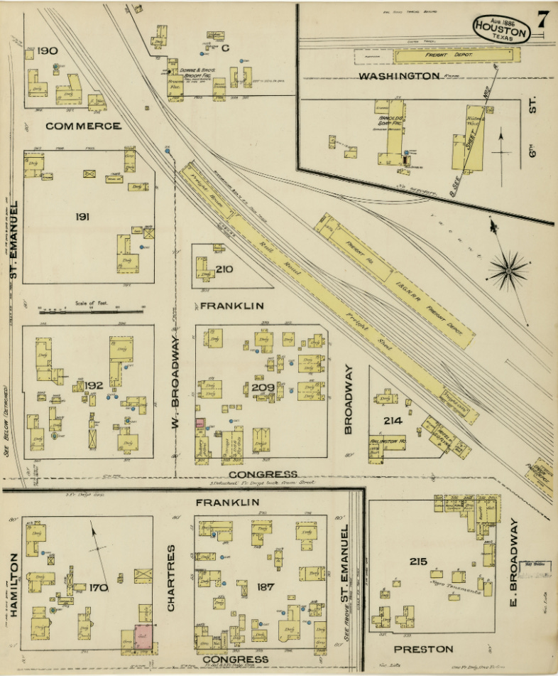
From 1874 through 1881, the IGN developed more than 300 miles of track, running west from the Brazos River to Central Texas and to the Rio Grande Valley. While the GHH did not grow in the 1880s, the Galveston, Harrisburg & San Antonio was already merging into a much larger rail network. The year it formed in 1870, it acquired the 83 miles of the Buffalo Bayou, Brazos & Colorado railroad. It expanded west to San Antonio by 1877. The Houston Second Ward railroad depots, therefore, by the early 1880s, were regional hubs for railroad passengers and freight from east, central, and south Texas. These same railroad depots ere major employers, attracting workers to the neighborhood. Sanborn Insurance Company mapped this area in detail for the first time in 1885 (Image 3 and Image 4).3
Image 3. 1885 Sanborn Map of Houston, Key Map. Perry-Castañeda Map Collection, University of Texas Libraries, Digital Archives. Annotated by author.
Image 4. 1885 Sanborn Map of Houston, Facet 7. Perry-Castañeda Map Collection, University of Texas Libraries, Digital Archives.
Charles P. Zlatkovich, Texas Railroads: A Record of Construction and Abandonment (Austin: University of Texas, Bureau of Business Research, 1981), 26; George C. Werner, “History of the Galveston, Houston and Henderson Railroad Company,” 1976, updated 14 February 2017, Handbook of Texas Online; Andrew Forest Muir, “Railroads Come to Houston 1857–1861,” Southwestern Historical Quarterly 64, no. 1 (1960): 50-1.
Augustus Koch, “1873 Birdseye Map of Houston,” Madison, WI, J.J. Stoner, 1873, Wikipedia Commons; Tracey & Barker, compilers, Houston City Directory for 1873 (Houston: Tracey & Barker, 1873), 2, 12, 36; Zlatkovich, Texas Railroads, 27-8, 69-70, 73-5; David G. McComb, Houston: A History (1969; Austin: University of Texas Press, 1981), 28-9; Louis F. Aulbach, Buffalo Bayou: An Echo of Houston’s Wilderness Beginnings (Houston: Louis F. Aulbach, 2012), 480-1; George C. Werner, “History of the Galveston, Houston and Henderson Railroad Company,” 1976, updated 14 February 2017, Handbook of Texas Online; George C. Werner, “History of the International-Great Northern Railroad Company,” 1976, updated 4 April 2017, Handbook of Texas Online. George C. Werner, “History of the Galveston, Harrisburg & San Antonio,” 1952, updated 1 September 1995, Handbook of Texas Online.
Zlatkovich, Texas Railroads, 75; “1885 Sanborn Map of Houston, Key Map and Facet 7,” Perry-Castañeda Map Collection, University of Texas Libraries, Digital Archives; Richard J. Orsi, Sunset Limited: The Southern Pacific Railroad and the Development of the American West, 1850-1930 (Berkeley, CA: University of California Press, 2005), 22; Werner, “History of the Galveston, Houston and Henderson Railroad Company”; “History of the International-Great Northern Railroad Company”; History of the Galveston, Harrisburg & San Antonio.”


